Top Stories
Development of Tothill Street: A Historical Overview of Frankleigh Park
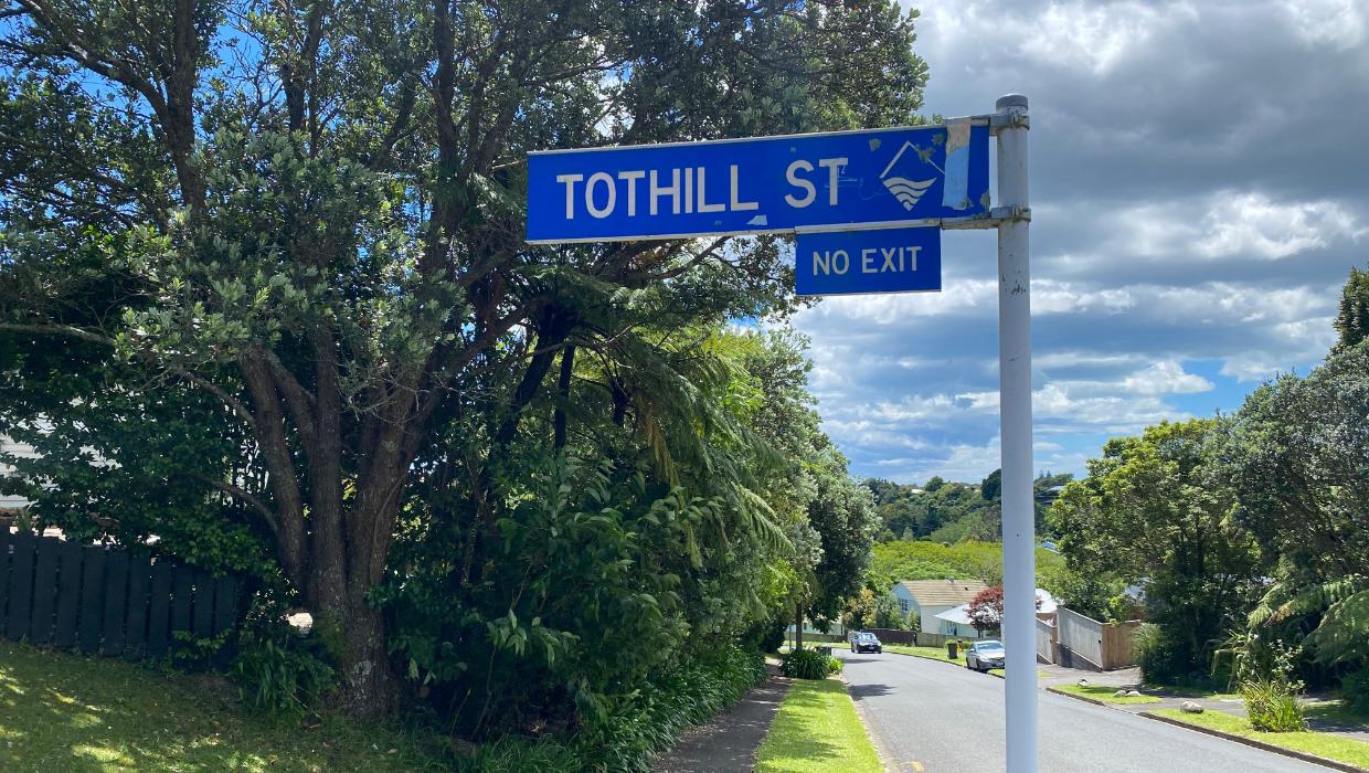
Tothill Street, located in Frankleigh Park, is a cul-de-sac that branches off Glenpark Avenue and lies in close proximity to the bustling Brois Street. This area has a rich history, particularly stemming from post-World War II developments aimed at addressing housing shortages for returning soldiers.
Government Initiatives and Housing Development
In 1947, the New Zealand government initiated several ambitious state housing projects, targeting economic recovery and providing homes for veterans. The housing division of the Public Works Department began negotiations to acquire approximately 86 acres (35 hectares) of land, which encompassed nearly the entire Huatoki Valley. This plan aimed to create space for around 400 residences.
Following the approval of the Huatoki Valley project by Cabinet, the Taranaki Daily News published a detailed development plan in 1948. The plan illustrated a winding road through the valley, designated locations for homes, proposed landscaping, and a recreational area situated near a broad bend in the Huatoki Stream. Notably, the layout depicted in this drawing closely resembles the current configuration, with Tothill Street prominently marked at the valley’s head.
Preliminary work commenced on the site in early 1949, although the project was somewhat scaled back from its original vision. Nonetheless, the goal remained to establish a “garden suburb” comprising around 200 houses. By the following year, the first homes were completed, becoming available for rent or purchase, often facilitated by low-interest government loans.
The Origin of Tothill Street’s Name
The street name, Tothill, draws inspiration from a thoroughfare of the same name in Plymouth, England. This naming convention was common at the time, as many streets in the area were chosen from a list of Plymouth names. The choice of Tothill holds some significance, as the name derives from Old English, where ‘tōt’ means lookout and ‘hyll’ translates to hill. This is particularly fitting for Tothill Street, which is positioned at the valley’s apex, providing a vantage point over Glenpark Avenue.
The historical details surrounding Tothill Street reflect a broader narrative of post-war recovery efforts in New Zealand, highlighting how government initiatives laid the foundation for modern communities. For those interested in exploring more about the history of local streets and developments, resources are available through the Taranaki Research Centre at Puke Ariki. Their archive includes numerous street histories, offering insights into the evolution of urban landscapes in the region.
For further information and a comprehensive collection of street histories, visit the Puke Ariki website at https://terangiaoaonunui.pukeariki.com/story-collections/word-on-the-street.


New $25 Million Funding Boosts Hospital Capacity Ahead of Winter

Discover Sleep Space’s Affordable Bach Bed Packages Today

Jury Dismissed in Sexual Assault Trial Over Misguided Questions

Wellington’s New Gallery Unveils Community-Driven Art Exhibition

All Whites Face Challenges as Injuries Strike Before World Cup

Heroic Bystander Rescues Swimmers from Dangerous Surf in Napier

Nina Oyama Returns to Crime Comedy in Deadloch Season 2

China Southern Airlines Offers Reliable Journey from Auckland to Vietnam

Nina Oyama Returns to Deadloch for Anticipated Season 2

Community Mourns Teens Lost in Mount Maunganui Landslide

Tributes Pour In for Lachlan Rofe, Reality Star, Dead at 47

Private Funeral Held for Dean Field and His Three Children

Funeral Planned for Field Siblings After Tragic House Fire

Netball New Zealand Stands Down Dame Noeline Taurua for Series

Julian Dennison Ties the Knot with Christian Baledrokadroka in New Zealand

New Research Reveals Simple Path to Enhanced Happiness

New ‘Maverick’ Chaser Joins Beat the Chasers Season Finale

Al Waha Motors Opens Flagship Jetour Showroom in Al Khor
-
 Top Stories6 months ago
Community Mourns Teens Lost in Mount Maunganui Landslide
-
 Entertainment10 months ago
Tributes Pour In for Lachlan Rofe, Reality Star, Dead at 47
-
 World8 months ago
Private Funeral Held for Dean Field and His Three Children
-
 Top Stories8 months ago
Funeral Planned for Field Siblings After Tragic House Fire
-
 Sports10 months ago
Netball New Zealand Stands Down Dame Noeline Taurua for Series
-
 Entertainment6 months ago
Julian Dennison Ties the Knot with Christian Baledrokadroka in New Zealand
-
 Science9 months ago
New Research Reveals Simple Path to Enhanced Happiness
-
 Entertainment9 months ago
New ‘Maverick’ Chaser Joins Beat the Chasers Season Finale
-
 Health6 months ago
Al Waha Motors Opens Flagship Jetour Showroom in Al Khor
-

 Lifestyle10 months ago
Maia Wilson Faces Backlash Following Taurua’s Suspension
-

 Sports9 months ago
All Blacks Star Damian McKenzie and Partner Announce Baby News
-

 Sports10 months ago
Silver Ferns Legend Laura Langman Criticizes Team’s Attitude